Degraded Land, Sustainable Palm Oil, and Indonesia’s Future
-----------------
A new policy to develop oil palm on degraded land could protect Indonesia’s forests. But what does “degraded” really mean?
In May 2010, Indonesian President Susilo Bambang Yudhoyono declared a policy to develop oil palm plantations on “degraded land” instead of forest or peatland. As part of national REDD+ strategy to be developed under a groundbreaking $1 billion partnership with Norway, this policy has the potential to allow the palm oil industry to continue to expand—generating profits, government revenues, and jobs—while reducing greenhouse gas emissions from deforestation and forest degradation.
Although questions remain regarding the details of Indonesia’s strategy to reduce emissions from deforestation and forest degradation (REDD+), the Indonesian government has recently suggested that there are 6 million hectares of degraded land (an area larger than the Indonesian province of Aceh) that could be used for oil palm expansion—enough to achieve the country’s national target of doubling palm oil production by 2020 without additional deforestation.
Whether the expansion of oil palm plantations on degraded land is sustainable will depend largely on how important details—such as the meaning of “degraded”—are addressed during implementation.
Debating Definitions: What is “Degraded Land?”
Past estimates of the extent of degraded land in Indonesia have ranged widely—from 12 to 74 million hectares—as some studies have used definitions limited to biophysical characteristics such as tree canopy cover while others have included social or economic considerations.
A degraded land policy designed to reduce emissions from deforestation should consider a “forest carbon” perspective—in other words, the use of degraded land for oil palm plantations should not lead to significant carbon emissions. Such degraded lands, for example, could be areas that were cleared of forests long ago and that now contain low carbon stocks and low levels of biodiversity, such as alang alang grasslands. In this sense, degraded land would have low standing biomass, low below-ground carbon storage and low forest regeneration potential.
Both industry and civil society groups are concerned that the location and status of the “degraded” areas referred to by the partnership—particularly from a social and legal standpoint—are unclear. Meanwhile, REDD+ policy-makers and environmental NGOs are concerned that allowing the conversion of “degraded” secondary forests could result in significant carbon emissions as well as lost “co-benefits” such as biodiversity preservation.
In addition, there is a significant and growing consensus—as reflected by growing industry participation in the Roundtable on Sustainable Palm Oil (RSPO) and in recent government statements—regarding the need to balance environmental, economic, and social concerns in order to ensure that the expansion of oil palm plantations is truly “sustainable.” This would include, but would not be limited to, whether an area is degraded from a forest carbon perspective.
A major challenge facing national REDD+ policy-makers and decision-makers at all levels is a lack of a common methodology—and the associated accurate and up-to-date spatial data—for identifying acceptable areas for sustainable oil palm plantation expansion.
Implementing a Degraded Land Policy for Sustainable Palm Oil
A Degraded Land Database
To address this challenge, the partnership has proposed to establish a “degraded land database.” A well-designed publicly available database would provide the necessary spatial data to implement a common methodology for identifying acceptable areas for expansion. A critical step toward determining what information needs to be included in this database is the development of a transparent and systematic methodology for prioritizing acceptable areas for sustainable palm oil development, that includes a working definition of degraded from a forest carbon perspective.
This step should be informed by ongoing related efforts by NGOs such as WRI, WWF, Conservation International, the Nature Conservancy and Fauna & Flora International and incorporate relevant industry or market guidelines such as those developed by the RSPO.
A Common Methodology for Identifying Degraded Land
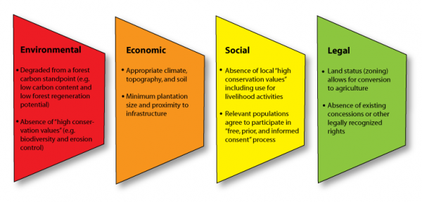
Under Project POTICO, WRI and Indonesian partner Sekala have developed a working methodology for identifying degraded land that is acceptable for sustainable oil palm plantation expansion. According to this methodology, an acceptable area would fulfill four criteria:
Environmental. The area is degraded from a forest carbon perspective. Developing the area will not result in significant greenhouse gas emissions or reduce critical environmental “high conservation values” including biodiversity preservation and clean water supply;
Economic. The area is biophysically capable of profitable oil palm production in terms of climate, topography, and soil properties. Highest priority areas meet minimum plantation size and proximity to infrastructure requirements;
Social. Local people are likely to benefit from plantation establishment and, if relevant, agree to participate in a process to obtain free prior and informed consent; and
Legal. Legal land status allows for conversion to oil palm plantation and expansion does not conflict with existing concessions or other rights including traditional rights of indigenous communities.
|
|
| Figure 1. Screening Criteria for Identifying Acceptable Areas for Sustainable Oil Palm Expansion |
These screening criteria are applied in a multi-step process consisting of a desktop analysis followed by field visits to assess individual sites (Figure 1). The desktop analysis uses relevant spatial data based on satellite information, aerial imagery, and other sources to assess factors that can be measured and mapped objectively—such as carbon content. Field work is required to verify the results of the desktop analysis and assess factors that can only be determined on a site level, especially those related to social acceptability.
 |
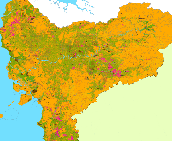
| Figure 2. This POTICO map of West Kalimantan identifies areas that have no/low potential (orange), medium potential (green), and high potential (pink) for sustainable oil palm expansion. |
WRI and Sekala recently applied this method to develop a map identifying potentially acceptable areas for sustainable oil palm plantation expansion in the province of West Kalimantan (Figure 2). This map was used to guide field assessments of over two dozen potential sites. This experience has shown that a process to determine whether or not an area is acceptable for sustainable oil palm expansion should consider that:
Environmental acceptability can be assessed and mapped using a combination of satellite data, aerial imagery, and on-the-ground field visits. However, available spatial data is currently not sufficiently accurate to confidently identify areas that are environmentally suitable without field verification.
Economic viability will vary between oil palm growers. Government officials can use screening criteria to generate maps of areas where it is possible to grow oil palm with reasonable yields based on climate, topography, and soil type. However, private companies will require additional information—such as proximity to infrastructure, the location of their existing operations, and mills—to determine which of these areas meet company-specific requirements for viability.
Social desirability needs to be determined through a participatory planning process that addresses “free prior and informed consent.” Information related to social desirability—including the current uses, claims, and traditional rights—is often unavailable prior to conducting fieldwork. Maps of acceptable areas can provide input into a participatory planning process but should not pre-determine where oil palm plantations are established.
Legal feasibility can be changed—and needs to be clarified—by policy-makers. Some areas that are acceptable according to environmental, economic, and social criteria may be currently unavailable to planters for legal reasons. For example, some of these degraded areas may be legally classified as forest where agricultural activities are not allowed. This does not mean, however, that the area should necessarily be removed from consideration as acceptable for sustainable oil palm plantations. These legal barriers can be removed by policy-makers. However, developing a transparent and fair process for removing legal barriers requires accurate information. Current spatial data regarding legal feasibility—such as the location of outstanding permits or other rights and claims—is often unavailable or inconsistent across multiple data sources.
To support this methodology, a comprehensive “degraded land database” would need to include sufficient spatial data to assess these environmental, economic, social, and legal criteria.
Actions for National Policy-Makers
The success of a national strategy to support the expansion of sustainable oil palm plantations on degraded lands rests with planning and management decisions by various groups and individuals. Important decision-makers will include national, provincial and district government officials, companies, and communities—for example, those involved in REDD+ strategy development, spatial planning and permitting, project planning, law enforcement, and MRV (measuring, reporting and verification). A “degraded land database” can inform all of these decision-makers.
National policy-makers can begin the implementation of an effective and equitable national policy to develop sustainable oil palm plantations on acceptable degraded areas by taking the following actions:
Ensure that the proposed “degraded land database” is designed to support improved planning and management decisions for sustainable palm oil. The database should contain comprehensive, accurate, and regularly updated spatial data and take the form of a publicly available and easily accessible web-based application that allows users to generate maps based on pre-determined screening criteria and user-defined parameters. To ensure the database is used effectively, the developers of the database should work with important decision-makers—including REDD+ policy makers, national and local government officials, private companies and civil society organizations—to collect input for database design, produce common definitions and methodologies, and develop appropriate awareness-raising and capacity-building activities.
Identify data gaps, establish a process for collecting and updating data on a regular basis, and facilitate data sharing between government agencies. Many datasets are not sufficiently accurate and are sometimes contradictory. Information that is as relevant as possible should be included in the database, and limitations of existing data should be publicly identified and explained.
Provide publicly available maps of areas that are degraded from a forest carbon perspective and a common methodology for identifying acceptable areas for sustainable oil palm expansion. Although some screening criteria such as social desirability can only be determined through site-specific fieldwork, a publicly available map of areas that fulfill the environmental and economic criteria can provide a common starting point for policy-makers, companies, and civil society.
Identify and remove legal barriers to the development of areas that are otherwise environmentally, economically, and socially acceptable. Unlike the other screening criteria, legal feasibility can be changed by policy-makers. Based on accurate spatial data, policymakers can develop land use zoning and permitting procedures to remove legal barriers to sustainable oil palm development in degraded areas. These procedures should be consistent with best practices in participatory spatial planning and the principle of free prior and informed consent.
If defined and designed effectively, the proposed “degraded land database” will help Indonesia achieve its low carbon and agricultural development goals through sustainable oil palm expansion on degraded land.
---------------


